


I shoot listings all over Central Texas, and I also sell them. That dual seat, REALTOR with Magnolia Realty and working photographer, is why I take real estate drone photography seriously instead of treating it as a gimmick. An aerial frame does something a ground-level shot simply cannot. It shows the lot lines, the roof, the pool, the trees, and how a home actually sits inside its neighborhood.
This is the honest version of the topic. What real estate drone photography costs, the FAA license you legally need before you fly a paid job, the gear I actually put in the air, and the shots that move buyers in Temple, Belton, Killeen, and Salado. No hype. Just what earns its place in a listing.
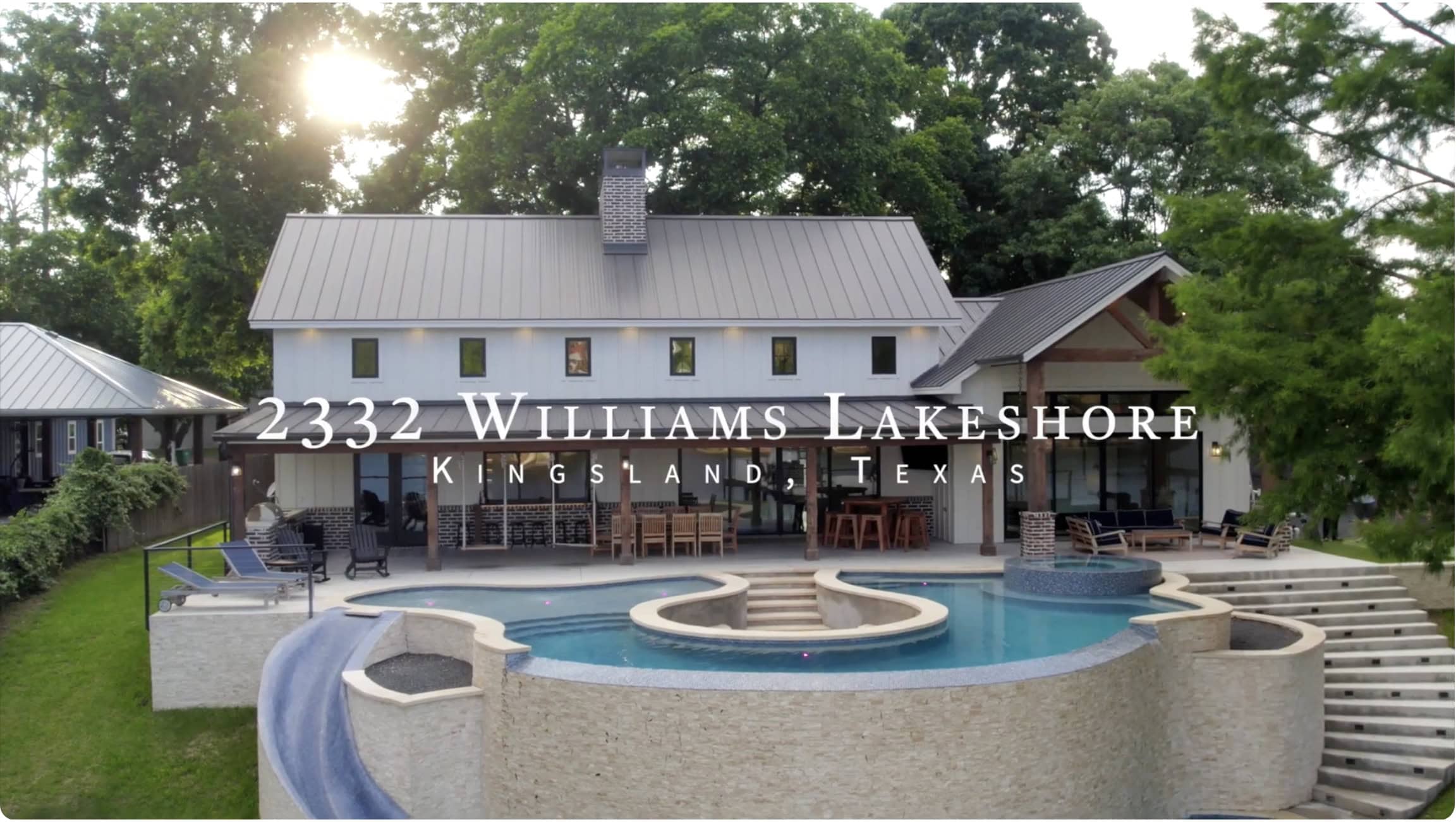
Buyers scroll fast. On a phone, your listing gets a second or two before a thumb keeps moving. A strong aerial stops that thumb. That is the whole job. Real estate drone photography gives a buyer instant context that ten interior photos cannot, because it answers the questions they ask first. How big is the yard? What backs up to the property? Is there a greenbelt, a busy road, a neighbor’s shop forty feet away?
Central Texas is exactly the market where this pays off. We sell homes on an acre outside Salado, ranchettes near Belton Lake, new builds in Harker Heights, and established neighborhoods in Temple where mature oaks tell the whole story from above. A ground photo flattens all of that. An aerial shows the buyer why the lot is worth the asking price.
There is a hard number people love to quote here. Listings that include aerial imagery tend to draw more clicks and more showing requests than listings without it. I will not pretend a drone sells a bad house. It does not. What it does is get the right buyer to stop, look, and book a showing on a home that fits them.
There is also a demand-side reality. Sellers now expect it. When I sit at a listing appointment in Killeen or Nolanville and walk through my media plan, the aerials are the part that makes a seller lean forward. Skipping real estate drone photography on a competitive listing feels, to a lot of sellers, like showing up with half the marketing.
Younger buyers reinforce it. The generation buying starter homes in Harker Heights grew up on video and expects to see a property from the air before they drive out. Real estate drone photography is quietly becoming table stakes for a serious listing, not a luxury reserved for the top of the market.
What real estate drone photography actually costs
Let me be straight about money, because the range online is all over the place. For a standard residential listing in our area, real estate drone photography add-ons usually land somewhere between one hundred and three hundred dollars when bundled with a full photo shoot. Standalone drone-only visits cost more per trip, because the pilot still has to load up, drive out, set up, and fly.
Several things move that number. Lot size matters, since a five-acre property needs more passes than a quarter-acre lot. Video costs more than stills, because editing a smooth aerial clip takes real time. Twilight aerials, where we fly at that narrow golden window after sunset, carry a premium for the timing and the extra processing.
Here is the part sellers do not always see. The price reflects a licensed, insured operator flying legal, not a hobbyist with a cheap quadcopter. Real estate drone photography done right includes FAA compliance, liability insurance, airspace checks, and an editing workflow. That overhead is exactly what separates a usable listing asset from a shaky clip that makes a nice home look amateur.
Cheap aerials are expensive in a different currency. A blown-out sky, a crooked horizon, or a jittery orbit tells buyers the seller cut corners. On a three hundred thousand dollar home, saving eighty dollars on media to lose a week of buyer attention is a bad trade. I would rather a seller spend nothing on aerials than spend a little on bad ones.
FAA Part 107: the license behind legal real estate drone photography
This is the part most homeowners never think about, and it matters more than the camera. Legal real estate drone photography lives and dies on this one credential. Flying a drone for any real estate listing is commercial work in the eyes of the federal government. That means the pilot must hold an FAA Part 107 Remote Pilot Certificate. Not a hobby registration. An actual certificate. Legal real estate drone photography starts here or it does not start at all.
Getting Part 107 is not casual. You must be at least sixteen, pass a TSA background vetting, and sit a sixty-question aeronautical knowledge exam at an approved testing center. You need seventy percent to pass, and the exam fee runs about one hundred seventy-five dollars per attempt. The test covers airspace classes, weather, sectional charts, and flight rules. It is a real exam, and people fail it.
The certificate does not last forever either. Every twenty-four months, a certificated pilot has to complete recurrent training to stay current. On top of that, nearly every drone flown commercially now has to broadcast Remote ID, which is basically a digital license plate the FAA can read in flight. Skipping any of this is not a paperwork technicality. Violations can carry fines reaching into the tens of thousands of dollars.
Why this protects the seller, not just the pilot
If an unlicensed flyer crashes into a car, a roof, or a person, the liability question gets ugly fast, and a seller does not want to be anywhere near it. When you hire a Part 107 pilot who carries insurance, you are buying a clean chain of accountability. Ask for the certificate number. A legitimate operator will hand it over without blinking, because legal real estate drone photography is a selling point, not a secret.
There is one more wrinkle worth knowing. Parts of Central Texas sit near controlled airspace, and Fort Cavazos shapes the map more than people realize. Flying near Temple, Killeen, or the training areas can require authorization through the FAA’s LAANC system before a legal takeoff. A local pilot who flies here every week already knows which addresses need a request and which do not. That knowledge is not on any spec sheet.
The gear I fly for real estate drone photography

Gear does not make the photographer, but for aerial work the drone matters, since sensor size and stabilization decide whether a shot is usable. If you are budgeting the whole package, my honest real estate photography cost guide breaks down what aerials and everything else should run. The good news in 2026 is that the tools are better and cheaper than they have ever been. My working rule for real estate drone photography is simple. Fly the smallest drone that still delivers a clean, large file and smooth video.
For premium listings and commercial work, the DJI Mavic 4 Pro sits at the top for most of us. It runs around twenty-two hundred dollars, shoots up to one hundred megapixel stills and 6K video, carries a variable-aperture triple-camera system, and flies for roughly fifty-one minutes on a charge. That flight time is not a luxury. It means fewer battery swaps and more time nailing the shot before the light shifts.
The value pick is the DJI Air 3S at about eleven hundred dollars. It gives you a one-inch main sensor, fifty megapixel stills, 4K video, a useful telephoto lens, and around forty-five minutes of flight. For the bread-and-butter residential listing, it is honestly all the drone most real estate drone photography jobs will ever need. I would rather see an agent hire a pro flying an Air 3S than a hobbyist flying something twice the price badly.
There is also a genuinely capable budget tier now. The sub-250-gram class, like the DJI Mini 5 Pro near eight hundred dollars, still captures 4K and fifty megapixel stills while weighing less than a can of soda. The light weight eases some registration rules, though commercial use still demands Part 107. For real estate drone photography on tight lots, these little drones are nimble and quiet.
The aerial shots that actually matter
More is not better. A listing does not need twenty aerials. It needs four or five that each say something specific. When I plan real estate drone photography for a Central Texas home, I shoot to a short list, not to whatever looks pretty in the moment. The best real estate drone photography is edited before the drone ever leaves the case.
The first is the hero. A clean, slightly elevated front frame that shows the house, the driveway approach, and the immediate lot, ideally with the sun behind me so the facade is lit. The second is the lot-context shot, higher up, revealing property boundaries, the backyard, and what surrounds the home. That one answers the question buyers care about most.
Then I want an amenity shot, tight on the pool, the shop, the covered patio, or the acreage, whatever makes this house different. A neighborhood or approach shot helps too, especially near a greenbelt, a park, or Belton Lake, since location sells as hard as the structure. If the budget includes video, a slow reveal orbit or a straight push toward the front door gives the listing a cinematic anchor for social media.
Twilight and the Central Texas sky
Twilight aerials are worth calling out. That short window where the sky goes deep blue and the interior lights glow is when a home looks its most expensive. It is harder to shoot, the timing is unforgiving, and it costs more. On the right luxury or lakefront listing in Salado or Belton, though, a single twilight aerial can become the photo that carries the whole campaign.
Local drone pilots versus national booking platforms

Here is where I get a little opinionated. A wave of national booking platforms will happily send a drone operator to your Central Texas listing. On the surface it looks convenient. Under the hood, most of those platforms work like dispatchers. They assign whoever is available and cheap that day, and the person who shows up may have flown your ZIP code exactly zero times.
That model squeezes two things at once. It drives the pilot’s pay down, which pushes experienced shooters out and pulls inexperienced ones in. And it strips away accountability, because the platform is a middleman, not the person standing on your driveway. When the aerials come back crooked or the flight gets flagged for airspace, there is no local owner to call. Good real estate drone photography depends on the person, not the app that dispatched them.
A local owner-operator is a different deal entirely. I fly Temple, Belton, Killeen, and the surrounding Central Texas towns every week, I know which addresses sit under Fort Cavazos airspace, and I know how our afternoon light behaves in July versus January. Real estate drone photography is a local craft as much as a technical one. When my name is on the work, I have skin in the game that no national platform can fake.
None of this is anti-technology. Book online if that fits your workflow. Just ask who actually shows up, whether they hold Part 107, and whether they carry insurance. The convenient answer and the good answer are not always the same person. If you are weighing your options, my guide to choosing the right real estate photographer walks through the exact questions to ask.
Weather, seasons, and flying in Central Texas
Drones and wind do not get along, and Central Texas has plenty of wind. A steady breeze under fifteen miles per hour is usually fine for a stable rig. Gusts above twenty start showing up as micro-jitters in video and can drain a battery fast as the drone fights to hold position. I watch the forecast the morning of every shoot and I will reschedule before I fly a listing in bad air.
Light is the other variable. Our summer sun climbs hard and high, which flattens midday aerials and blows out rooftops. I prefer the two hours after sunrise or the two before sunset, when shadows have shape and the sky holds color. Spring and fall give the most forgiving skies here, but a good pilot can make a January afternoon work with the right angle.
Season changes what the aerial is even selling. A lush April lawn photographs like a magazine. A dormant August yard needs a higher, wider frame that leans on the lot and the roofline instead of the grass. Adjusting the plan to the calendar is a small thing that separates real estate drone photography that helps a listing from filler that just fills a gallery. That kind of judgment is exactly what real estate drone photography by a local pro buys you.
A pre-flight checklist for sellers and agents
You do not need to know how to fly to help the shoot go well. A little prep makes real estate drone photography dramatically better, and most of it costs nothing.
Move the cars. Nothing kills a hero aerial like three vehicles in the driveway and a trailer on the street. Tidy the yard, since a drone sees every hose, toy, and trash can from above. Clean the pool and skim the leaves, because a green pool is glaring from the sky. Retract the trampoline or at least center it. Close the garage. Store the trash bins out of frame.
Then think about timing and access. Tell the pilot about any gate codes, dogs, or neighbors who might be curious. Share the lot lines if the property is on acreage, so the aerial frames the right boundaries. And ask, before booking, the two questions that actually matter for real estate drone photography. Do you hold Part 107, and are you insured. If the answer to either is soft, keep looking.
For a deeper walk-through of prepping the whole home for media day, grab our free Photo Prep Checklist. It covers the interior and exterior details that make every photo, aerial included, land better.
Quick answers: real estate drone photography FAQ
Do I legally need a licensed pilot for listing aerials?
Yes. Any drone flight tied to selling a home is commercial, so the pilot must hold an FAA Part 107 certificate. A neighbor with a hobby drone flying your listing is operating illegally, and that exposes everyone involved. Real estate drone photography for a live listing is not a place to cut that corner.
How much should aerials cost on a normal home?
For a typical Central Texas listing, expect roughly one hundred to three hundred dollars for real estate drone photography bundled with a photo shoot. Video, large acreage, and twilight flights push that higher. The price reflects a licensed, insured operator and a real editing workflow, not just the minutes in the air.
Will a drone help a starter home or only luxury listings?
Both, but differently. On a luxury or acreage property, aerials sell the land and the setting. On a starter home, a single lot-context shot can still answer buyer questions fast and set the listing apart. Right-sizing the shot list is what makes real estate drone photography pay off at any price point.
What if the property is near Fort Cavazos airspace?
Then you want a local pilot who knows the map. Flying near controlled airspace can require FAA authorization before takeoff. A shooter who works Killeen and Temple every week already knows which addresses need a request. That local knowledge is a real part of doing real estate drone photography right here.
The bottom line
Aerials are not a novelty anymore. They are part of how homes get sold in Central Texas, and buyers notice when they are missing. Done well, real estate drone photography answers a buyer’s first questions before they ever step inside, and it does it in the two seconds you have to earn a click.
Do it legally, do it locally, and do it with intent. Hire a Part 107 pilot who carries insurance, knows our airspace, and shoots to a plan instead of just launching and hoping. When you are ready, take a look at our real estate photography services and let us put your listing in the best possible light. That is the difference between an aerial that sells a home and one that just takes up space in the gallery.
Tim Kennedy is a REALTOR with Magnolia Realty Temple/Belton and a Central Texas real estate photographer with more than eight years behind the camera. He shoots and sells across Temple, Belton, Killeen, Harker Heights, and Salado, and believes the best listing media comes from a local pro with skin in the game.